

Tom a' Chasteil [Sir David Baird's Monument]
Good walks are even better shared.
NN8221 : Covid-19 notice, Trowan Wood
Richard Webb Photo source
Overview
Tom a' Chasteil [Sir David Baird's Monument]
Introduction
Nestled in the heart of the Scottish Highlands, Tom a' Chasteil stands as a proud sentinel over the landscape, with its elevation of 535 meters offering splendid views to those who venture to its summit. This Marilyn not only boasts geological interest but also a slice of Scottish history with the memorial of Sir David Baird adorning the top.
Geology
The mountain is primarily composed of metamorphic rocks, revealing its ancient origins. You might even feel like a geologist as you traverse the rocky paths, discerning the differences between schist and gneiss—don’t worry, nature lovers, there’s no exam at the end!
Routes
A popular route to the summit begins at the West Highland Way. The 7.5 km hike is moderately challenging, taking approximately 2.5 hours. With gentle ascents and stunning views throughout, this hike is highly recommended for those who enjoy a decent workout with a side of fresh air.
Summit Features
Upon reaching the summit, you'll be greeted by the striking monument dedicated to Sir David Baird. Standing tall and proud, it provides not just a sense of accomplishment but also a perfect photo opportunity.
Terrain
Expect a mixed terrain with rocky sections interspersed with grassy meadows and occasional boggy patches. It's advisable to wear sturdy footwear to avoid a not-so-graceful tumble!
Views
On a clear day, the panoramic views from the top are absolutely breathtaking. You’ll see Loch Awe stretching out beneath you and the jagged peaks of the surrounding hills. Spring and autumn are the best seasons for a visit, so pack your walking boots and get ready to soak up the scenery.
Hazards
As with many Highland walks, be mindful of the wet, boggy ground, and loose stones. A bit of careful footing will ensure you reach the top without an unexpected dip!
Nearby Summits
For the ambitious, nearby Ben Cruachan beckons with its lofty heights and magnificent vistas. Combine the hikes if you have the energy and time!
Access
Reaching the trailhead is straightforward, with parking available at NN 803 191. Regular buses serve Taynuilt, the nearest town, where you can stock up on snacks or enjoy a coffee before heading out on the trail.
Facilities
While facilities on the mountain itself are non-existent, Taynuilt offers cafes and shops to replenish your energy.
History
The name Tom a' Chasteil translates to 'Hill of the Castle,' reminding us of the rich history surrounding the area. The monument itself pays homage to Sir David Baird, a distinguished general whose legacy endures through this dedicated site.
In summary, Tom a' Chasteil is much more than just a hill; it’s a mix of challenging hikes, stunning nature, and rich Scottish history. So, lace up those boots and hit the trails—you won’t regret it!
Explore routes near Tom a' Chasteil [Sir David Baird's Monument]
Walks starting near this hill. Open a route to check its map, distance and full itinerary.
Crieff: Lady Mary's Walk and the River Earn
View route
Bridge of Allan Strollers and Stragglers
View route
Kenmore: Drummond Hill Black Rock Trail above Loch Tay
View route
Strathallan Court Strollers and Stragglers
View route
Route planning notes
These notes describe possible approaches. Check a route's map and access information when planning your walk.
West Highland Way Approach
Starting from the West Highland Way, this route gently ascends towards the summit, offering scenic views and an easy to follow path.
Make a day of it, together
Find someone to share the walk with, or organise a day out along a route you like.
Photo Gallery
View all Photo could not load
NN8221 : Covid-19 notice, Trowan Wood
Richard Webb
 Photo could not load
NN8221 : Track through Trowan Wood
Dr Richard Murray
 Photo could not load
NN8221 : Woodland Fern
Dr Richard Murray
 Photo could not load
NN8221 : Path, Trowan Wood
Richard Webb
 Photo could not load
NN8221 : Bluebells in Trowan Wood
Dr Richard Murray
 Photo could not load
NN8221 : Slopes of Tom a' Chasteil
Richard Webb
 Photo could not load
NN8221 : Trowan Farm
Dr Richard Murray
 Photo could not load
NN8221 : Farm road, Trowan
Richard Webb
 Photo could not load
NN8221 : Bluebells in the woods near Trowan
Dr Richard Murray

NN8221 : Obelisk on Tom a Chasteal
ronnie leask
Hill facts and local notes
Classifications
Elevation
133m
436 ft
Prominence
38m
Coordinates
56.3729, -3.9044
NN824216
OS Map
52 57
Explorer: OL47E 368E
At the Summit
At the summit, you will find Sir David Baird's Monument, a striking stone pillar that commemorates the achievements of the notable Scottish general.
Terrain & Geology
The mountain comprises primarily metamorphic rock, presenting a rocky surface that showcases the geological history of the region. The presence of schist and gneiss suggests significant tectonic activity in the past.
Views & Scenery
From the summit, you can gaze upon the impressive surrounding landscapes, including views towards Loch Awe and the distant peaks of the highlands.
History & Heritage
Name Origin
The name 'Tom a' Chasteil' translates to 'Hill of the Castle,' reflecting its historical significance.
Historical Significance
The monument is dedicated to Sir David Baird, who played a vital role in the Napoleonic Wars and is a reminder of Scotland's rich military history.
Getting There & Facilities
Parking
There is parking available at the start of the West Highland Way near NN 803 191, accommodating several vehicles with access to toilets.
Public Transport
Regular bus services run to nearby towns such as Taynuilt, from where the trail can be accessed.
Nearby Facilities
Although facilities are limited on the mountain, Taynuilt has cafes and shops where you can grab a bite or stock up on supplies before your hike.
Safety Information
Known Hazards
- Be cautious of the potentially wet and boggy ground; proper footwear is essential.
- Loose rocks can present a hazard when ascending or descending, so watch your step!
General Safety Tips
- Check weather conditions before setting out
- Carry appropriate clothing and equipment
- Let someone know your planned route
- Take a map, compass, and GPS device
- Carry emergency supplies: food, water, first aid kit, torch
Hills
Some common questions about the hills answered
Are there group walks up Tom a' Chasteil [Sir David Baird's Monument]?
Many walkers use Walkmates to join or organise walks with others. You can check for group walks around Tom a' Chasteil [Sir David Baird's Monument] through the maps
Are there other walkers around Tom a' Chasteil [Sir David Baird's Monument]?
Activity varies by location and time, but Walkmates lets you see whether others have shared walks or shown interest in this area. Find other people through the walking friends search walking friends for Tom a' Chasteil [Sir David Baird's Monument] search or of course create your own walk for Tom a' Chasteil [Sir David Baird's Monument]
Can I organise a walk to Tom a' Chasteil [Sir David Baird's Monument]?
Yes. If there aren’t any walks listed already, you can create a walk and make it available for others to join.
If you're signed up to Walkmates, you can create a walk to Tom a' Chasteil [Sir David Baird's Monument].
How do I find a walk up this hill?
There are often multiple ways to walk this hill, depending on experience and route preference. Walkmates helps you explore walks and routes that others have shared.
Can I suggest a new route up Tom a' Chasteil [Sir David Baird's Monument]?
Yes. You can suggest or create routes to share with others. Walkmates focuses on the social side of walking, so routes are used to help people organise walks and explore areas together, rather than as detailed navigation tools or route libraries.
Other uses really appreciate knowledgeable walkers sharing their routes. Share your favourite route to Tom a' Chasteil [Sir David Baird's Monument] here
The is an error or something incorrect about this hill. How do I let you know?
We always strive to keep the information on Walkmates as accurate as possible. If you find an error, please let us know through the contact form and we'll aim to correct it as quickly as possible
Community Discussion
Comments
Location
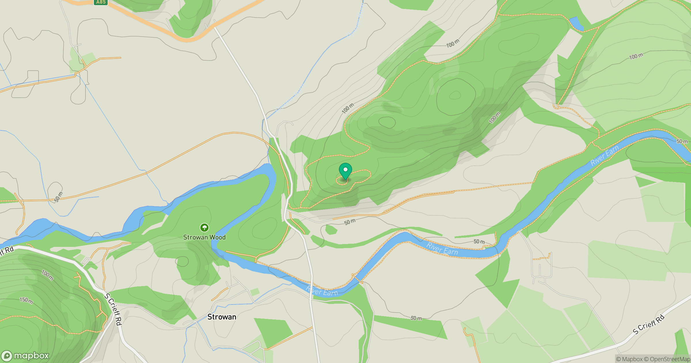
Grid reference: NN824216
View on OpenStreetMapOpens a map in a new tab, centred on the hill.
No comments yet. Be the first.